From Bulbapedia, the community-driven Pokémon encyclopedia.

|
The picture used in this article is unsatisfactory.
Please feel free to replace it so it conforms to Bulbapedia conventions.
Reason: Guidebook labels.
|
Hoenn
Route 112
|
112番道路
Route 112
|
|
|
|
Map description
| This route is popular among Trainers because it offers the chance to stroll while gazing up at Mt. Chimney.
|
|
|
Required for navigation

|
None
|
|
|
| Connecting locations
|
Location

Location of Route 112 in Hoenn.
|
| Pokémon world routes
|
Route 112 (Japanese: 112番道路 Route 112) is a route in central Hoenn, connecting Route 111, Lavaridge Town, Mt. Chimney, and the Jagged Pass. The route is divided into two segments by Mt. Chimney. The Fiery Path is located on the route, connecting the two segments.
Route description
The majority of this route is situated around the base of Mt. Chimney. Most of the route consists of uneven rocky terrain, although there is some tall grass in the lower areas. When entering the route from the south, the path to Lavaridge Town is visible to the west, but cannot be taken since it contains many ledges. Route 112 also provides a way to reach Route 113 and Fallarbor Town through the Fiery Path.
The Cable Car Base Station is located here, which takes passengers up Mt. Chimney.
West of the Cable Car Base Station is the southern entrance of Fiery Path. This short cave can be used to bypass the desert which cannot be entered without the Go-Goggles. The northern end of Route 112 also connects to the northern exit of Fiery Path.
Cable Car
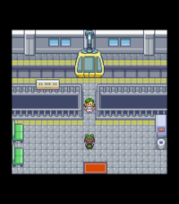
The Cable Car in Generation III
The Cable Car Base Station here can be used to travel up to the summit of Mt. Chimney, where the Jagged Pass leads south to Lavaridge Town. West of the Jagged Pass's southern entrance is Lavaridge Town, while the ledges to the east offer a shortcut back to the lower portion of the route.
Before confronting Team MagmaREOR/Team AquaSAS at Meteor Falls, Grunts block the entrance to the Cable Car station.
In Generation III, there is a 1/64 chance a Hiker, Camper, or Picnicker can be seen climbing the mountain when going up or down Mt. Chimney using the Cable Car.
Also in Generation III, the upper Cable Car station is considered a part of Mt. Chimney; in Generation VI, both Cable Car stations are considered part of Route 112.
Vending Machine
In Pokémon Omega Ruby and Alpha Sapphire, there is a Vending Machine at both Cable Car stations. The drinks are sold for twice their normal price.
Items
Pokémon
Generation III
| Pokémon
|
Games
|
Location
|
Levels
|
Rate
|
|
|
R
|
S
|
E
|
|
14-16
|
25%
|
|
|
R
|
S
|
E
|
|
14-16
|
25%
|
|
|
R
|
S
|
E
|
|
14-16
|
75%
|
| A colored background means that the Pokémon can be found in this location in the specified game. A white background with a colored letter means that the Pokémon cannot be found here.
|
Generation VI
South section
| Pokémon
|
Games
|
Location
|
Levels
|
Rate
|
|
|
OR
|
AS
|
|
13-16
|
40%
|
|
|
OR
|
AS
|
|
13-16
|
60%
|
| Horde Encounter
|
|
|
OR
|
AS
|

|
Horde Encounter
|
|
8
|
35%
|
|
|
OR
|
AS
|
|
|
Horde Encounter
|
|
8
|
65%
|
Exclusively as hidden Pokémon
After defeating or catching Groudon/Kyogre
|
|
|
OR
|
AS
|
|
16
|
??%
|
|
|
OR
|
AS
|
|
16
|
??%
|
|
|
OR
|
AS
|
|
16
|
??%
|
|
|
OR
|
AS
|
|
16
|
??%
|
| A colored background means that the Pokémon can be found in this location in the specified game. A white background with a colored letter means that the Pokémon cannot be found here.
|
North section
| Pokémon
|
Games
|
Location
|
Levels
|
Rate
|
|
|
OR
|
AS
|
|
14-17
|
35%
|
|
|
OR
|
AS
|
|
14-17
|
65%
|
| Horde Encounter
|
|
|
OR
|
AS
|
|
|
Horde Encounter
|
|
8
|
35%
|
|
|
OR
|
AS
|
|
|
Horde Encounter
|
|
8
|
65%
|
Exclusively as hidden Pokémon
After defeating or catching Groudon/Kyogre
|
|
|
OR
|
AS
|
|
17
|
??%
|
|
|
OR
|
AS
|
|
17
|
??%
|
|
|
OR
|
AS
|
|
17
|
??%
|
|
|
OR
|
AS
|
|
17
|
??%
|
| A colored background means that the Pokémon can be found in this location in the specified game. A white background with a colored letter means that the Pokémon cannot be found here.
|
Trainers
Pokémon Ruby and Sapphire
| Trainer
|
Pokémon
|

|
|
|
Camper Larry
キヨフミ Kiyofumi
Reward: $288
|
|
|
|
|
|
|
|
|
|
|
|
|
|
|

|
|
|
Hiker Trent
ケンサク Kensaku
Reward: $640
|

|
|
|
|
|
|
|
|
|
|
|
|
|
|
|
Hiker Brice
ハルノブ Harunobu
Reward: $720
|
|
|
|
|
|
| Rematch
|
|
|
|
|
Hiker Trent*
ケンサク Kensaku
Reward: $960
|
|
|
|
|
|
|
|
|
|
|
|
|
|
Hiker Trent*
ケンサク Kensaku
Reward: $1080
|
|
|
|
|
|
|
|
|
|
|
|
|
|
Hiker Trent*
ケンサク Kensaku
Reward: $1200
|
|
|
|
|
|
|
|
|
|
|
|
|
|
Hiker Trent*
ケンサク Kensaku
Reward: $1320
|
|
|
|
|
|
|
|
|
|
| Trainers with a PokéNav by their names will be registered in the Trainer's Eyes or Match Call function after the first battle, and may have a rematch with the player with higher-level Pokémon.
|
Pokémon Emerald
| Trainer
|
Pokémon
|
| South section
|
|
|
|
|
Camper Larry
キヨフミ Kiyofumi
Reward: $288
|
|
|
|
|
|
|
|
|
|
|
|
|
|
|
|
|
Hiker Trent
ケンサク Kensaku
Reward: $640
|
|
|
|
|
|
|
|
|
|
|
|
|
|
Hiker Brice
ハルノブ Harunobu
Reward: $680
|
|
|
|
|
|
| North section
|
|
|
|
|
|
|
|
|
|
|
| Rematch
|
|
|
|
|
Hiker Trent*
ケンサク Kensaku
Reward: $960
|
|
|
|
|
|
|
|
|
|
|
|
|
|
Hiker Trent*
ケンサク Kensaku
Reward: $1080
|
|
|
|
|
|
|
|
|
|
|
|
|
|
Hiker Trent*
ケンサク Kensaku
Reward: $1200
|
|
|
|
|
|
|
|
|
|
|
|
|
|
Hiker Trent*
ケンサク Kensaku
Reward: $1320
|
|
|
|
|
|
|
|
|
|
| Trainers with a PokéNav by their names will be registered in the Trainer's Eyes or Match Call function after the first battle, and may have a rematch with the player with higher-level Pokémon.
|
Pokémon Omega Ruby and Alpha Sapphire
| Trainer
|
Pokémon
|
| South section
|
|
|
|
Camper Larry
キヨフミ Kiyofumi
Reward: $288
|
|
|
|
|
|
|
|
|
|
|
|
|
|
|
|
Hiker Trent
ケンサク Kensaku
Reward: $544
|
|
|
|
|
|
|
|
|
|
|
|
|
|
Hiker Brice
ハルノブ Harunobu
Reward: $576
|
|
|
|
|
|
| North section
|
|
|
|
| Rematch
|
|
|
|
|
|
|
|
|
|
|
|
|
|
|
|
|
|
|
|
|
|
|
|
|
|
|
|
|
| Trainers with a PokéNav by their names will be registered in the Trainer's Eyes or Match Call function after the first battle, and may have a rematch with the player with higher-level Pokémon.
|
Appearance
Trivia
- The Cable Car base station is the only building in Ruby, Sapphire, and Emerald that is on a route and plays the same background music as the route where it's located.
- When using the Cable Car, PoochyenaRS or ZigzagoonE was supposed to be one of the sprites that could appear with a 1/64 chance. However, due to a programming error, they will never appear.
See also