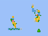
File:Sevii Islands Seven Island Map.png
No higher resolution available.
Sevii_Islands_Seven_Island_Map.png (192 × 144 pixels, file size: 1 KB, MIME type: image/png, looped, 2 frames, 0.7 s)
Note: Due to technical limitations, thumbnails of this file will not be animated.
| This file is from the Bulbagarden Archives. The description from its description page there is shown below. |
Summary
| This image is an animated PNG file. | ||
|---|---|---|
| Both Nate and Rosa are animated in this template; however, some older browsers are limited to showing only the first frame of animated png files. If neither Trainer is moving in your browser, do not change the image. |
| This is an in-game map of the Sevii Islands region from Pokémon FireRed and LeafGreen, with Seven Island highlighted. |
Licensing:

This image is a screenshot from a Pokémon game, or substantially derived from one.
The contributor claims this to be fair use.
File history
Click on a date/time to view the file as it appeared at that time.
| Date/Time | Thumbnail | Dimensions | User | Comment | |
|---|---|---|---|---|---|
| current | 20:01, 13 October 2012 | | 192 × 144 (1 KB) | Lady Ariel | Fixed location |
| 21:42, 29 September 2012 | 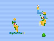 | 192 × 144 (1 KB) | Lady Ariel | Animated | |
| 03:43, 4 September 2006 |  | 192 × 144 (2 KB) | TTEchidna | Map of the last three Sevii Islands, highlighting Seven Island for the Cities and Towns Bulbapedia Project. Created using MSPaint and a map of the Sevii Islands from FireRed/LeafGreen. {{i-PD-user|TTEchidna}} |
File usage
The following 3 pages use this file:
Metadata
Categories
- No categories associated with this article